Before you can publish an import project, there are two checks that must be done manually. The first is that of the stray. If you have not selected Addresses, you can skip to Correct errors
Vial conversion
Street names should not be imported as they come from Cadastre. They violate OSM rules (they are in capital letters, without accents and with other problems). CatAtom2Osm helps to correct them by automatically matching the name of each road in Cadastre with the most similar and closest name in OSM. If it does not find a match it performs a preliminary transformation as a suggestion of what the correct name should be. In any case, it is necessary to review the process manually.
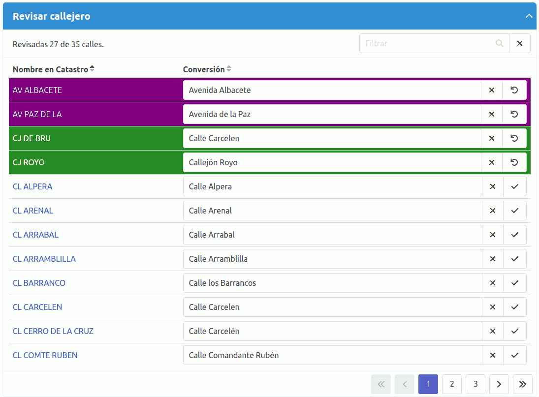
The review is done using this table. In the left column the Name in Cadastre of the vial is shown, in the right column the proposed Conversion.
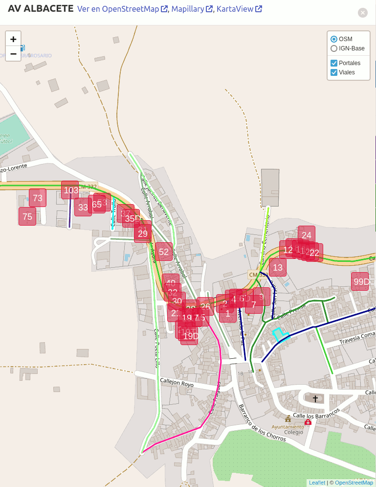
When you click on a row, a map appears that shows the existing Cadastre portals on that street and the existing roads in OSM. Click on the portals to access the Cadastro facade photos. Placing the mouse over a vial displays the name in OSM.
 © OpenStreetMap
You can use the layer selector to switch between the OSM map and the IGN-Base map that shows the Cartociudad street map, or to deactivate the Portals or Roads layers if they do not allow you to see the map well.
Validation
Following the Cadastre portals, look for which OSM vial they correspond to.
If the street has a name in OSM, it is correctly written, it is the same as the proposed conversion and it corresponds to the name that appears in the Cadastre, you can validate the conversion using the button
The rows of the reviewed streets are shown with a different color for each user who has made the review. You can also check it by hovering your mouse over the street name edit box. Different users can collaborate to complete the review.
Correction
If the street does not have a name in OSM, or if it has one but it is not the same as the proposed conversion, look for the correct name using field review or the different available sources (Cartociudad, facade photos, Mapillary, KartaView).
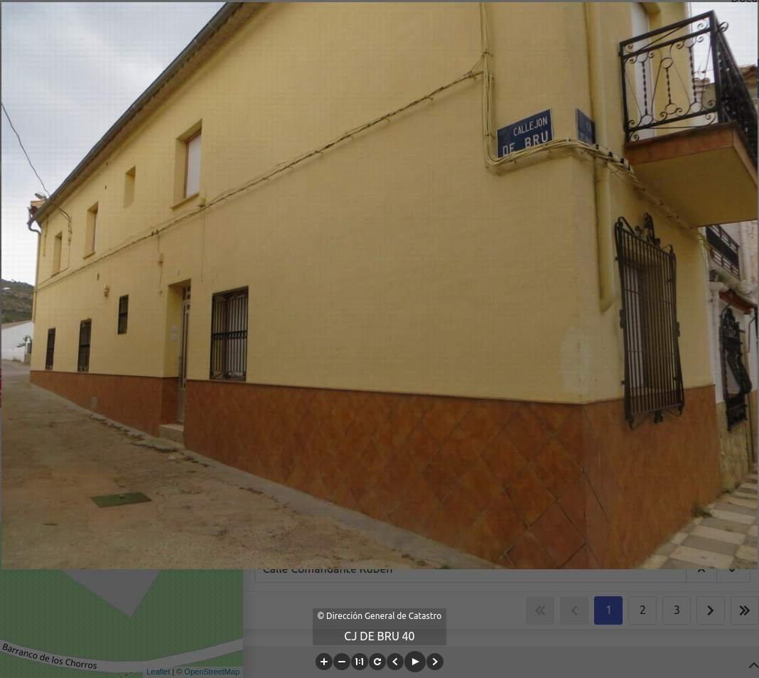 © Dirección General de Catastro
When you have the correct name edit the conversion in the table and/or the path name in OSM as necessary. To access and edit the map, in the map header there is a link to the OSM website.
Edits to the map resulting from this phase must be made with the regular OSM user account, not with dedicated import accounts. It is advisable to label them with #1calle1nombre and the name of the municipality in the comment of the set of changes.
If a street is shown with different colors along its layout, it is because it is made up of different roads in OSM and the name does not match. You have to edit the map, see which one is correct and put it in all the sections. In this example, the name in a section is missing an accent.
 © OpenStreetMap
When the program does not find a path in OSM to match the names with, it will apply corrections to the name in Cadastre to suggest it as a conversion. Monitor the conversion of road type abbreviations. There are some that have several possible values that are shown separated by a bar. These are the cases of AL (Aldea/Alameda), CJ (Calleja/Callejón) or CR (Carretera/Carrera), for example. If you use them, check that only the correct type of track remains or none, as the case may be.
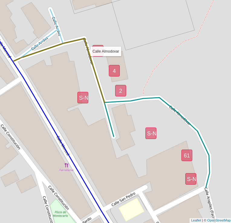
Some Cadastre addresses may refer to places instead of roads, for example to neighborhoods, urbanizations, hamlets.
Checks if the name is mapped in OSM or can be added.
Note that the program maps addresses to the tag addr:place=* instead of addr:street=* when the name begins with place references.
For a complete list see the annex.
Eliminate
Some Cadastre road names may not be suitable for import into OSM. For example, we can find administrative references such as 'MANZANA A SECTOR 4' that do not correspond to real road names. If you decide not to import addresses for a road name, leave the conversion blank using the Delete button
Undo
To restore the conversion to its original value use the button
Reprocess
When the street map review is complete, the user who started the process can continue to the next step using the button
Annex: Acronyms for road type
ABREV.           ESPAÑOL                    CATALÁ                   GALEGO
AG               Agregado*                  Agregat*                 Engadido*
AL               Aldea*/Alameda             Llogaret*                Aldea*/Alameda
AR               Área*/Arrabal              Àrea*/Raval              Área*/Arrabalde
AU               Autopista                  Autopista                Autoestrada
AV               Avenida                    Avinguda                 Avenida
AY               Arroyo                     Rierol                   Regato
BJ               Bajada                     Baixada                  Baixada
BO               Barrio*                    Barri*                   Barrio*
BR               Barranco*                  Barranc*                 Cavorco*
CA               Cañada*                    Camí ramader*            Canella*
CG               Colegio*/Cigarral*         Col·legi*/Cigarral*      Colexio*/Cigarreiro*
CH               Chalet*                    Xalet*                   Chalet*
CI               Cinturón                   Cinturó/Ronda            Cinto
CJ               Calleja/Callejón           Carreró                  Calexa/Quella/Ruela
CL               Calle                      Carrer                   Rúa
CM               Camino/Carmen              Camí                     Camiño/Carme
CN               Colonia                    Colònia                  Colonia
CO               Concejo*/Colegio           Ajuntament*/Col·legi     Concello*/Colexio
CP               Campa*/Campo*              Camp*                    Campeira*/Campo*
CR               Carretera/Carrera          Carretera                Estrada/Carreiro
CS               Caserío*                   Mas*                     Caserío*
CT               Cuesta/Costanilla          Costa/Rost               Costa/Pendente
CU               Conjunto*                  Conjunt*                 Conxunto*
CY               Caleya                     Carreró                  Caleya
DE               Detrás                     Darrere                  Detrás
DP               Diputación*                Diputació*               Deputación*
DS***            Diseminados                Disseminats              Espallado
ED               Edificios*                 Edificis*                Edificios*
EM***            Extramuros                 Extramurs/Raval          Extramuros
EN               Entrada*/Ensanche*         Entrada*/Eixample*       Entrada*/Ensanche*
ER               Extrarradio*               Extraradi*/Raval         Arrabalde*
ES               Escalinata                 Escalinata               Escalinata
EX               Explanada                  Pla                      Chaira
FC               Ferrocarril/Finca*         Ferrocarril              Ferrocarril/Finca*
FN               Finca*                     Finca*                   Finca*
GL               Glorieta                   Rotonda/Plaça            Glorieta
GR               Grupo*                     Grup*                    Grupo*
GV               Gran Vía                   Gran Via                 Gran Vía
HT               Huerta*/Huerto*            Hort*                    Horta*/Horto*
JR               Jardines*                  Jardins*                 Xardíns*
LD               Lado/Ladera                Marge/Vessant            Costado/Ladeira
LG               Lugar**                    Lloc**                   Lugar**
MC               Mercado*                   Mercat*                  Mercado*
ML               Muelle*                    Moll*                    Peirao*
MN               Município*                 Municipi*                Concello*
MS               Masías*                    Masies*                  Masías*
MT               Monte*                     Muntanya*                Monte*
MZ               Manzana*                   Illa*                    Mazá*
PB               Poblado*                   Poblat*                  Poboado*
PD               Partida*                   Partida*                 Partida*
PJ               Pasaje/Pasadizo            Passatge                 Pasaxe/Pasadizo
PL               Polígono*                  Polígon*                 Polígono*
PM               Páramo*                    Erm*                     Páramo*
PQ               Parroquia*/Parque          Parròquia*/Parc          Parroquia*/Parque
PR               Prolongación/Continuación  Prolongació/Continuació  Prolonga/Continuación
PS               Paseo                      Passeig                  Paseo
PT               Puente                     Pont                     Ponte
PZ               Plaza                      Plaça                    Praza
QT               Quinta                     Quinta                   Quinta
RB               Rambla                     Rambla                   Rambla
RC               Rincón/Rincona             Racó                     Recuncho/Cornecho
RD               Ronda                      Ronda                    Rolda
RM               Ramal                      Branc                    Ramal
RP               Rampa                      Rampa                    Rampla
RR               Riera                      Riera                    Riera
RU               Rúa                        Rua                      Rúa
SA               Salida                     Sortida                  Saída
SD               Senda                      Sender                   Sendeiro
SL               Solar*                     Solar*                   Soar*
SN               Salón                      Saló                     Salón
SU               Subida                     Pujada                   Costa
TN               Terrenos*                  Terrenys*                Terreos*
TO               Torrente                   Torrent                  Torrente
TR               Travesía/Transversal       Travessera               Travesía/Transversal
UR               Urbanización*              Urbanització*            Urbanización*
VR               Vereda                     Sendera                  Carreiro/Verea
AC               Acceso                     Accès                    Acceso
AD               Aldea                      Llogaret                 Aldea
BV               Bulevar*                   Bulevard*                Bulevar*
CZ               Calzada                    Calçada                  Calzada
PA               Paralela                   Paral·lel                Paralela
PC               Placeta/Plaça              Placeta/plaça            Prazola
PG               Polígono                   Polígon                  Polígono
PO               Polígono                   Polígon                  Polígono
SB               Subida                     Pujada                   Costa
SC               Sector*                    Sector*                  Sector*
CALLEJON         Callejón                   Carreró                  Quella/Ruela
CANTON           Cantón                     Cantó                    Cantón
CIRCUNVALACION   Circunvalación             Circumval·lació          Circunvalación
GENERICA         Genérica                   Genérica                 Xenérica
JARDIN           Jardín*                    Jardí*                   Xardín*
MALECON          Malecón                    Malecón                  Dique
RINCON           Rincón                     Racó                     Recuncho
PROLONGACION     Prolongación               Prolongació              Prolonga
TRANSITO         Tránsito                   Trànsit                  Tránsito
TRAVESIA         Travesía                   Travessera               Travesía
VIA              Vía                        Via                      Vía
*) Applies to addr:place instead of addr:street.
**) Applies to addr:place and removes the "Place" prefix in the conversion
***) The addresses of these types are removed.